

Newfoundland & Labrador’s
Burin Peninsula
Captain Cook Drive
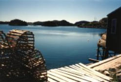
Captain Cook Drive is a network of roads and communities branching from Mortier Bay and Burin Bay
to Winterland. It is rich in history and folklore.
It begins east, across the Canning Bridge from Marystown, to Little Bay and Beau Bois, pronounced
("Bo Boys"). This was the areas major community in the early 19th century with it's long beach and
protected harbour. Jerome Walsh's Museum (closed for renovations) is a cozy fishing premises in
Little Bay. It holds an excessive amount of personal items collected by the now deceased fisherman.
The Little Bay Heritage Community Centre, originally a church, was floated over from Oderin Island.
Beau Bois Museum is the site of the original schoolhouse.
Over a period of five years (1763-1767) the famous navigator and cartographer Captain James Cook
spent summers navigating the coasts of Newfoundland. His goal was to create the first accurate maps
of the area, complete with sailing directions and advice on safe anchorage. Find out more by
continuing on route 210 through Creston South and on through to route 221 to Burin.
To keep an eye out for smugglers, illegal French fishing boats, plus French & American "privateers",
Captain Cook used one of the best vantage points in the Burin area. The lookout still bears his name
and is an interesting hike in the surrounding hills offering a spectacular view. Historic Man O' War Hill
is another splendid vantage point.
The 13 coves and settlements that make up present day Burin hold 300 years of history. Communities, span a wide geographical
area from the Salt Pond valley to the steep cliffs of the "Scrape", the road intertwining the hills and the homes of historic Burin.
Burin extends inland 8 km from the sea in a terrain protected from the open sea by offshore islands that provide shelter from wind
and storm. Basque fishermen have been said to have visited Burin as far back as 1650. Burin may have been named by a French
sailor while standing on the deck of a ship holding an awl type tool. He was astonished by the resemblance between the burine and
the harbour.
By 1740, there were four British ships operating out of the Burin and Mortier Harbours. The settlement was formed when over 300
people began spending their winters in Burin. The fishery became the basis for the Burin economy, and by the early 20th century
the community became the chief town on the peninsula, with it's prosperous inshore and bank fishery.
A blend of the old and the new has become the slogan for Burin. Its Heritage Square setting gives you a tremendous insight into
the history of Burin and the island of Newfoundland. Bull's cove, Port au Bras, Fox Cove/Mortier and the Tide's Point lighthouse are
found on a breathtaking steep winding coastal drive north.
Southwest again route 220 leads you to two choices: Route 222 to Winterland or 220 through Lewin's Cove, site of the admired Freshwater Pond Park, communities of Salmonier
and Epworth, the end of Captain Cook Drive. Corbin, an abandoned fishing community, is a popular cabin and cottage area. If you choose to head west on route 222 inland, you
will find the Winterland Eco Museum and trail in an outdoor migratory bird wetland setting and also learn of it's fishers-to-farmers history. Check out the beautiful nearby sandy
beaches of Golden Sands.
©2019 Heritage Run Tourism Association · All Rights Reserved

The Heritage Run Tourism Association
P.O. Box 757 · Marystown, NL
Canada · A0E 2M0
Tel: 709) 279-1887 ·Fax: (709) 279-5116
Email:theheritagerun@gmail.com


Newfoundland & Labrador’s
Burin Peninsula
Captain Cook Drive
Captain Cook Drive is a network of roads
and communities branching from Mortier
Bay and Burin Bay to Winterland. It is rich in
history and folklore.
It begins east, across the Canning Bridge
from Marystown, to Little Bay and Beau
Bois, pronounced ("Bo Boys"). This was the
areas major community in the early 19th
century with it's long beach and protected
harbour. Jerome Walsh's Museum (closed
for renovations) is a cozy fishing premises in Little Bay. It holds an excessive amount of
personal items collected by the now deceased fisherman. The Little Bay Heritage Community
Centre, originally a church, was floated over from Oderin Island. Beau Bois Museum is the site
of the original schoolhouse.
Over a period of five years (1763-1767) the famous navigator and cartographer Captain James
Cook spent summers navigating the coasts of Newfoundland. His goal was to create the first
accurate maps of the area, complete with sailing directions and advice on safe anchorage.
Find out more by continuing on route 210 through Creston South and on through to route 221
to Burin.
To keep an eye out for smugglers, illegal French fishing boats, plus French & American
"privateers", Captain Cook used one of the best vantage points in the Burin area. The lookout
still bears his name and is an interesting hike in the surrounding hills offering a spectacular
view. Historic Man O' War Hill is another splendid vantage point.
The 13 coves and settlements that make up present day Burin hold 300 years of history.
Communities, span a wide geographical area from the Salt Pond valley to the steep cliffs of the
"Scrape", the road intertwining the hills and the homes of historic Burin.
Burin extends inland 8 km from the sea in a terrain protected from the open sea by offshore
islands that provide shelter from wind and storm. Basque fishermen have been said to have
visited Burin as far back as 1650. Burin may have been named by a French sailor while
standing on the deck of a ship holding an awl type tool. He was astonished by the resemblance
between the burine and the harbour.
By 1740, there were four British ships operating out of the Burin and Mortier Harbours. The
settlement was formed when over 300 people began spending their winters in Burin. The
fishery became the basis for the Burin economy, and by the early 20th century the community
became the chief town on the peninsula, with it's prosperous inshore and bank fishery.
A blend of the old and the new has become the slogan for Burin. Its Heritage Square setting
gives you a tremendous insight into the history of Burin and the island of Newfoundland. Bull's
cove, Port au Bras, Fox Cove/Mortier and the Tide's Point lighthouse are found on a
breathtaking steep winding coastal drive north.
Southwest again route 220 leads you to two choices: Route 222 to Winterland or 220 through
Lewin's Cove, site of the admired Freshwater Pond Park, communities of Salmonier and
Epworth, the end of Captain Cook Drive. Corbin, an abandoned fishing community, is a popular
cabin and cottage area. If you choose to head west on route 222 inland, you will find the
Winterland Eco Museum and trail in an outdoor migratory bird wetland setting and also learn of
it's fishers-to-farmers history. Check out the beautiful nearby sandy beaches of Golden Sands.
©2019 Heritage Run Tourism Association · All Rights Reserved


